Alright, buckle up folks. Been down a real rabbit hole this past week trying to nail down where the heck Vinland actually was. You know, that place Leif Erikson supposedly found way before Columbus? Yeah, that one. Started off thinking it’d be simple – just read the sagas, match up the descriptions, boom, done. Man, was I wrong.
The Frustrating Start
Sitting down with the coffee – strong, black, the way you need it when staring at old texts – I cracked open the Saga of the Greenlanders and the Saga of Erik the Red. Classic stuff. They talk about Vinland having wild grapes, salmon rivers, and shorter winters than Greenland. Sounds cozy, right? Figured Canada, obviously. Newfoundland popped into my head first. Everyone always points to L’Anse aux Meadows. But something felt… off.
See, the sagas mention sailing west and south from some place called ‘Markland’ (which everyone kinda agrees is Labrador). Then, they hit this land with vines. Vines mean grapes, grapes need warmer climate. Newfoundland in the summer? Maybe you get some berries, but grapes? Proper grapes? That nagged at me. Kept sipping cold coffee, staring at maps on the screen. Newfoundland summers are nice, but grape-growing nice? Doubted it.
Drowning in Maps and Guesses
Then I dove into the wild west of online theories. Oh boy. Place is a circus. Everyone and their grandma has a spot:
- Some guys swear it’s Nova Scotia. Alright, warmer, grapes can grow there maybe.
- Others yell about New Brunswick, up the Saint John River.
- Heard someone seriously arguing for Maine, USA! Coastal Maine with Vikings? Interesting…
- Then you got the truly out-there folks pointing south, way south, almost to Rhode Island or beyond. Seriously?
Hours went by. Tabs multiplying like rabbits. Felt like I was chasing my own tail. How do you prove any of this? Archeology at L’Anse aux Meadows confirms Vikings were there, solid proof. But was that just a base camp? Was Vinland itself actually further south? The sagas talk about exploration from there… so maybe it was just the starting point?
The Clues That Made Sense (Sort Of)
Took a break, stepped away. Needed real air, not just coffee fumes. Came back later, eyes less blurry. Focused on what the sagas actually described:
- Grapes: Needed evidence wild grapes grew far enough north back then. Turns out, before the Little Ice Age kicked in harder around 1300-ish, climate was slightly warmer. Wild grapes did grow along the Atlantic coast up to maybe New Brunswick, possibly Nova Scotia. Maine… pushing it. Newfoundland? Extremely unlikely.
- Salmon in Rivers: That fits pretty much everywhere from Labrador down. Not much help.
- Timber: Mentioned as good quality, plentiful. Again, fits lots of places.
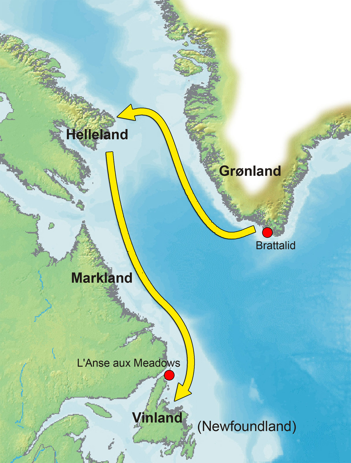
- The Route: West from Greenland, hit Helluland (Baffin Island?), then Markland (Labrador?), then south to Vinland. Going south implies moving towards warmer zones from the cold north.
So L’Anse aux Meadows? Logical base. Perfect spot for overwintering, repairing ships, launching further south. But Vinland proper? The land flowing with vines and ideal pastures? Probably further down.
My Best Shot
After all this digging, staring at satellite images, reading climate studies… my money settled on the Gulf of St. Lawrence coast. Think northern Nova Scotia, maybe the Chaleur Bay area in New Brunswick. Why?
- It’s significantly warmer in summer than Newfoundland. Wild grape range checks out better here.
- Abundant good wood. Plenty of rivers with salmon.
- The sailing route makes sense – after passing the Strait of Belle Isle (between Labrador/Newfoundland and Quebec), you head south hugging the coast.
- Still far enough north to be “west” relative to Norway/Iceland/Greenland sailing routes, but definitively south of Greenland and the colder Labrador coast.
Is it certain? Hah! Absolutely not. Zero solid archeological proof pinpoints Vinland south of Newfoundland. L’Anse aux Meadows is the only concrete Viking site in North America (outside Greenland). But logic, the sagas, and the environmental clues? They pile up pointing southward along that coast.
So yeah, spent days doing this, got weird looks from the cat, drowned in coffee, probably developed a map-induced squint. Is Vinland finally explained? Sorta? Maybe? Got a lot smarter about Norse navigation and North American climate shifts circa 1000 AD, I’ll tell you that much. Makes you realize finding it was likely an incredible achievement… and pinpointing the exact spot today? That’s still one hell of a puzzle.