Just pulled up Google Maps thinking this would be simple, wanted to actually see how the Niger stacks up against the famous Nile. Figured I’d just eyeball it real quick for the blog. Yeah, right.
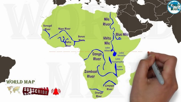
Typed in “Niger River” and zoomed out… and out… and out some more. Where the heck is the mouth of this thing? Spent a good five minutes panning around West Africa like a lost tourist, clicking along the coast. Finally spotted that big delta pouring into the Atlantic, south of Nigeria. Wasn’t all that bright, I know. Shoulda started from the ocean.
Okay, map pinned for the Niger. Time for the Nile. That one’s easy – found its giant squiggle slicing through Egypt fast, draining into the Med. Plunked a pin at its mouth too. Now the fun part: actually comparing them head-to-head.
First shocker: Location
Hit “Measure Distance” for each. The Nile? Damn, it starts crazy deep down south, below Lake Victoria, all the way up north to Egypt. Crosses like ten countries. Insane journey.
The Niger? Looked shorter at first glance? Wrong. Traces this huge backwards ‘C’ starting in Guinea, arches up into Mali near Timbuktu (yeah, that Timbuktu!), then plunges southeast through Niger and Nigeria. Also crosses a bunch of borders. Not the straightforward river I pictured.
Size matters… or does it?
Now, the big question: how long? Everyone knows the Nile’s king, right? Pulled out the measuring tool again. Sloowly traced the blue line for the Nile. My finger got tired. Over 6,650 km according to the pop-up! Ridiculous.
Then the Niger. Traced its weird loop-de-loop. Way less exhausting. Came out around 4,200 km. Big difference! Felt like comparing a marathon runner to a long-distance sprinter.
Drainage basin was next. Searched this separately, didn’t trust the map for that. Nile basin is gigantic, covering something like 3.3 million km²? Almost a third of Africa! The Niger basin? Still huge, don’t get me wrong – somewhere around 2.1 million km² – but definitely feels the smaller cousin.
Personal Takeaways:
- Big Fat Loop: I had zero clue the Niger did that massive inland bend. Makes the map look weird. Why doesn’t it just go straight? Blows my mind.
- Length Isn’t Everything: Seeing them side-by-side? Yeah, Nile’s the champ for length, no contest. But tracing the Niger’s path? That river has way more character with its wild shape. Feels unique.
- Different Worlds: Their endings tell the story. Nile = Mediterranean vibes, ancient Egypt history. Niger? Ends in the bustling Atlantic tropics. Completely different worlds, both shaping huge chunks of the continent.
- Map Tools Fight Back: This “simple” idea took forever. Seriously, Google Earth was lagging like crazy zooming in on those deltas. My cheap laptop nearly caught fire.
So yeah, bottom line? Nile’s longer, drains more land. Obvious winner on paper. But seeing the Niger’s crazy journey laid out? Makes you appreciate both of them way more. That wild curve it takes – never would’ve guessed it without actually mapping it myself. Geography lesson achieved, even if my map skills clearly aren’t great by any means. If NASA’s calling? Tell ’em I’m busy struggling with river deltas.