So I’ve been rereading “The Odyssey” lately, right? Got totally hooked on how Homer describes all these wild islands and monsters. But man, trying to picture where Odysseus actually sailed drove me crazy. Places called Scheria or Ogygia – ever heard of ’em? Me neither. Figured maybe drawing it out would help.
Why I Even Bothered
Honestly, started cause I got mixed up reading three different translations. One map online showed Ithaca near Greece, another plopped it near Italy. Which one’s real? Made my head spin. Thought, “Screw it, I gotta track this journey myself.” Wanted to see if these places matched real spots or if Homer just made them up.
First thing? I grabbed a huge sheet of paper – like poster-sized. Needed space. Started scribbling a rough Mediterranean outline from memory. Messed up Italy three times – kept making it look like a boot with high heels. Ended up grabbing an atlas later.
The Real Headache Begins
Sat down with an old paperback Odyssey (the spine’s all cracked) and a pencil. Went line by line. Started with Troy. Easy, that’s modern Turkey. Marked it with a big ‘X’. Smooth sailing so far, right?
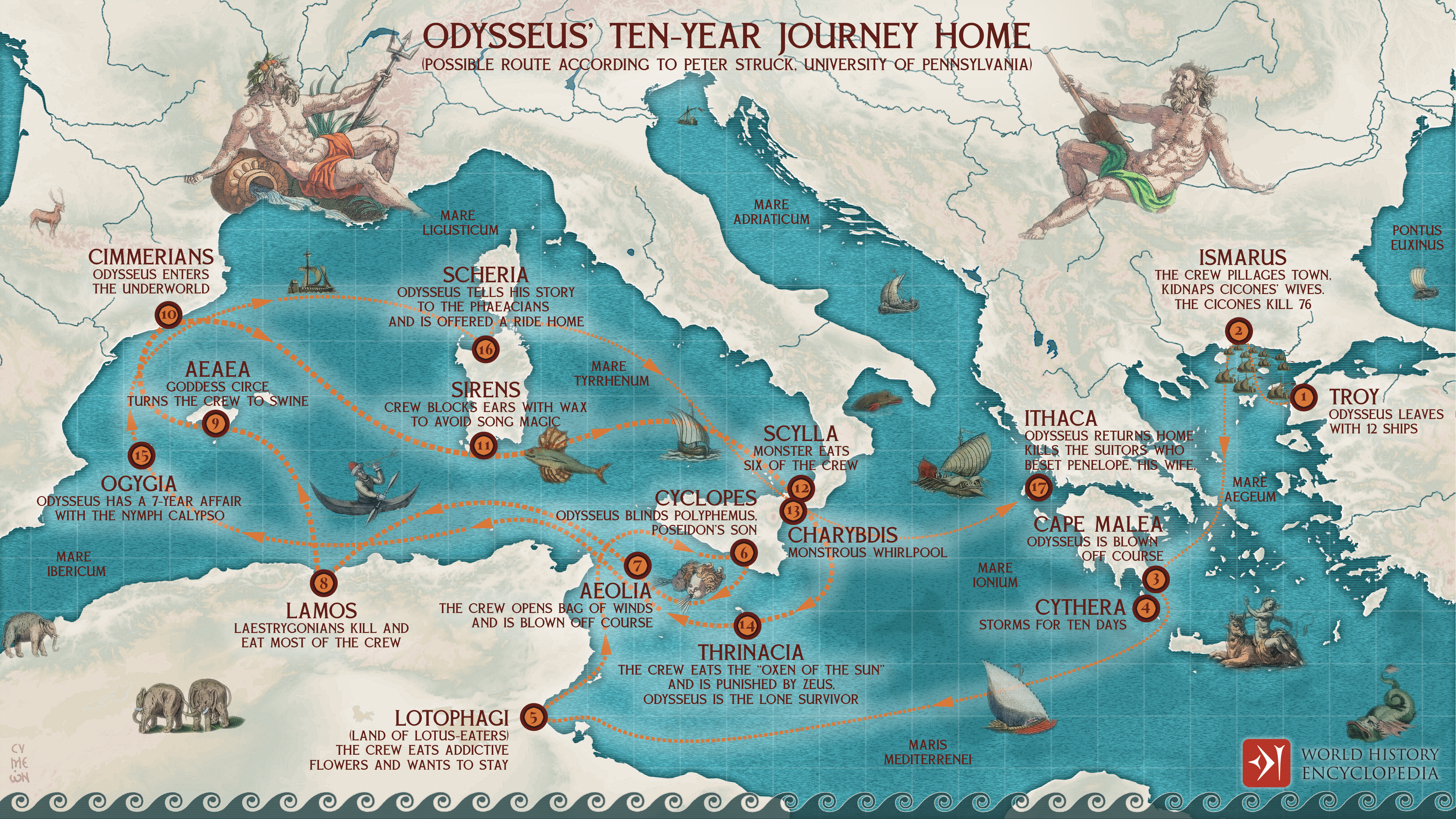
Next up: Ismaros, land of the Cicones. Book says it’s in Thrace. Looked Thrace up – northern Greece/bulky bit of Turkey. Okay, drew a dot. Then came the storm blowing ships waaaay off course.
Here’s where it got messy:
- Lotus Eaters land: No clue. Some say Libya coast? Just put a star near Africa with “???”
- Cyclops island: Sicily maybe? Got arguments for that. Smudged my pencil drawing a sheep icon there.
- Aeolus’ floating island: Pure fantasy? Probably. Drew a cloud with sad face.
- Laestrygonians: Total nightmare giants. Some maps stick them in Sardinia. Others say Sicily again. Flipped a coin.
- Circe’s Aeaea: Most point to Italy. Drew a tiny witch hat. Got kinda artsy.
Things Got Weirder
Then came the Underworld entrance. Where the heck do you put that on a physical map? Book said “Ocean’s end” or something cosmic. Nearly tore my hair out. Ended up drawing a dotted line to a skull symbol off the coast, muttering “This is pointless.”
Scylla and Charybdis? Okay, Strait of Messina between Italy and Sicily. That actually fits! High-fived myself for that one.
The Sun God’s cattle island? Thrinacia. Sicily again? Or Malta? Ran out of room near Sicily so slapped it somewhere south. Probably wrong.
Calypso’s Ogygia – seven years stuck there! Everyone argues over this one. Malta? Pantelleria Island? Made a frustrated squiggle in the middle of the sea.
Finally, Scheria – Phaeacian land. Book describes it super close to Ithaca. Okay cool. Marked it near modern Ithaca with a little ship. Felt good.
What the Map Showed Me
Stepped back. Whole paper looked like a toddler attacked it with crayons. Lines zig-zagging wildly across the Med, huge gaps where Odysseus got blown off course.
- Big Realization #1: Most “locations” are fuzzy. Homer wasn’t a geography teacher. Trying to match perfectly? Waste of time. It’s about story landmarks.
- Big Realization #2: The journey feels chaotic because Homer made it chaotic. Storms, monsters, gods messing with him – the messy map captures that lost feeling Odysseus had.
- Big Realization #3: Trying to pin down mythical places like Ogygia is like trying to catch smoke. They represent obstacles & trials, not literal GPS points.
Folded the map up. Still looks like a mess. But hey, drawing it out myself made me get why Odysseus felt so freaking lost. Homer knew his stuff – the disorientation is the whole point. Trying to make it neatly fit real geography? Yeah, turns out that misses the adventure.