Recently I’ve become a bit obsessed with American history, especially the big events that changed the fate of our country.While watching a documentary, I came across the term “Louisiana Purchase” and thought: it would be interesting to see this land deal represented on a map, wouldn’t it?
So I decided to draw my own map to show the amazing deal in 1803.I didn’t want to copy an old map from a textbook, but wanted a simple, clear, at-a-glance version.After all, not everyone can tell at a glance where the boundaries were back then.
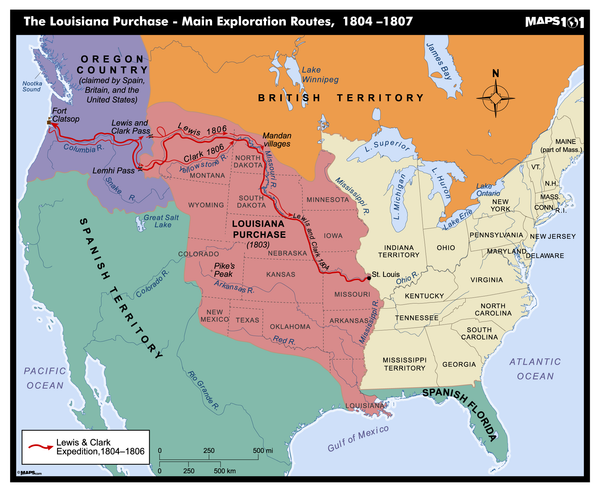
Step 1: Figure out which land is being bought.
The first thing you have to figure out is exactly what land the U.S. bought from France.It turns out that then-President Thomas Jefferson spent $15 million dollars to buy about 828,000 square miles of land from Napoleon.That’s a huge area, almost a quarter of what is now the United States!
I looked up quite a bit of information to confirm this information.But strangely enough, different sites actually say different things.Some maps showed the area a little to the east, others to the west.I later realized that because modern mapping technology was not available at that time, many of the boundaries were blurred.
I took notes as I compared the old maps to the current state boundaries.Piles of printed sketches littered my desk with my various questions, “Why does this river make a bend here?”, “Was Missouri really not a state then?”
Start drawing: simple tools can make good maps.
I didn’t use any specialized software, I just opened up a free map design app and drew directly by hand on my tablet.First, I drew the basic outline of the United States, then I marked the eastern part of the United States before 1803 with blue lines.Then, I filled in the newly acquired area with green.
At first, the green portion looked particularly abrupt, like a strange extra piece of graphics that had suddenly appeared.I iterated three times to more accurately represent the extent of the land.In the middle of the process, I had a problem with the app crashing, which almost made me drop my pen.But then I learned my lesson and saved every time I drew a small section.
Add landmarks: to give the map a sense of story.
Colors alone are not enough, I also wanted to add a few key locations on the map so that people can better understand the significance of this land purchase.I chose three key cities:
New Orleans: this was the central port for the entire trade, and control of this place meant control of the Mississippi River trade.
St. Louis: which later became the starting point for the Lewis and Clark expedition.
Missouri River Valley: this was their main route for exploring new territories.
For the fonts, I used a font with a bit of a vintage flair for the old place names, while the modern states are labeled with bolded capital letters.This distinguishes the era without looking too cluttered.
There was also a little niggle: should I label the land that Spain claimed to own but didn’t end up being counted?My friend suggested that I should not be too particular about the details and simply added some thin stripes to indicate these disputed areas, which is both aesthetically pleasing and historically accurate.
Final check: make sure the map is clear and easy to understand.
Next came the finishing touches.I added a simple compass icon and scale to make the map look complete.Once the first draft was complete, I posted it to a group of history buffs for people to see if there were any problems.
Sure enough, someone pointed out, “Hey, you don’t seem to have the Arkansas Territory in the right place!”So I went back and adjusted the western boundary.After all, a map should not only look good, but be accurate.
It was finally exported to PNG and JPG format for easy sharing.Looking at this map, I suddenly realized that it really was an incredible moment in history when France sold such a large piece of land for less than 4 cents per acre.
Conclusion: a map, a history.
Through the process of drawing this map about the Louisiana Purchase, I gained a deeper understanding of this history.It not only changed the map of the United States, but also laid the foundation for later expansion.
If you are also interested in history, try to understand some major events in a map way.You’ll find that geography and history are actually closely connected and it’s really interesting to see them presented visually!