Let me tell you this 1939 map thing kicked off totally unexpected. Was cleaning out my grandma’s dusty attic last weekend, right? Stumbled over this crazy old trunk full of crumpled papers and this one massive, stained map practically jumped out at me. Spit out half my coffee lifting it – huge thing, reeked of mothballs. Smoothing it out on the floor, Europe looked all weird, wrong somehow. Couldn’t figure it out until I spotted the tiny print: “1939”. Boom. That pre-war Europe. My brain kinda froze. We always learn about the war, but how it looked right before? Blank spot for me.
Decided right then I wanted to really understand this map, not just glance. Grabbed my notebook and a cheap red pen. Pulled up some modern atlas maps online for comparison – side-by-side. Needed to see how borders changed. My apartment floor became the command center: granny’s map on the left, laptop on the right, notebook balanced precariously.
The digging began hardcore:
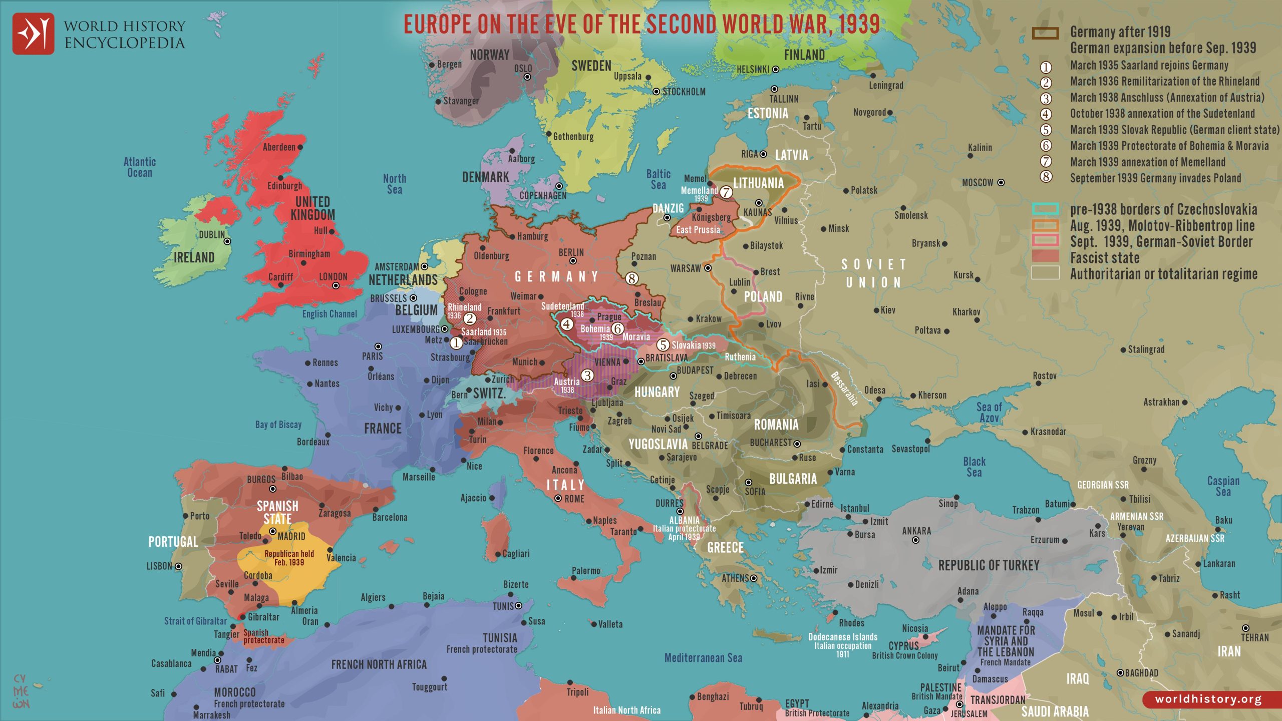
- Started with Germany. Big surprise! Remembered they took Austria and parts of Czechoslovakia before the war officially exploded in September 1939? This map? Yeah, already shows Austria completely gone, gobbled up as part of Germany. That Sudetenland piece? Already detached from Czechoslovakia and shoved under German control. The Czech lands were just “Bohemia and Moravia” on here, labeled a “Protectorate”. Slovakia was suddenly this separate little puppet state. Wild to see the cracks forming.
- Poland looked… normal? Until you remember what happened literally just months later. The map shows it whole, totally unaware it’s sandwiched right between the future axe-wielders. Feels eerie knowing this geography was doomed.
- Eastern Europe was a total headache factory. Countries like Lithuania and Latvia? Still independent according to this map. But we know their clock was ticking hard. Yugoslavia was this big block of color, solid on paper. Knowing it fractured internally later just added this layer of sad tension looking at it.
- Then there’s the Soviet Union. Looked huge, obviously. But right next door? Finland. The map shows the border calm. Yet we know the Winter War was about to blow wide open. Little things like the Baltics – Estonia, Latvia, Lithuania – still colored differently than the giant red blob to the east. Makes you hold your breath knowing how soon that changed.
Flipping constantly between my pen scribbles, the yellowed 1939 paper, and the modern digital map was making me dizzy. One moment particularly stuck: I found this tiny place labeled “Danzig” on the 1939 map, squeezed next to Germany. Free City, apparently? Scratched my head. Digging deeper, realized it was the huge international fight over this port city, one of the actual sparks that lit the powder keg later in ’39. Seeing it marked so plainly, a tiny spot holding massive tension? Wow.
So after hours sprawled on the floor, squinting at faded ink and screen glare, what really smacked me?
- This map isn’t truth. It’s a frozen moment right before total chaos erupted. Borders are fluid ghosts on paper, governments are trembling dominos.
- The big takeover moves – Austria, Czechoslovakia – were already done deals before the tanks rolled into Poland. The invasion wasn’t the start of the bullying; it was just the loudest act.
- Seeing all these small nations clustered together, trying to look confident on paper while the giants beside them flexed? Actually seeing it, not just reading “allies” and “axis”, makes it brutally real. Their futures were terrifyingly uncertain in that exact moment captured on grandma’s map.
- The sheer scale of ignorance was chilling. Every school kid staring at this map back then? They likely had no clue their world was weeks away from obliteration. Gives you chills.
Leaning back finally, my back aching and coffee cold, I looked down at the messy notes, the marked-up photocopies I made, the laptop screen. More than just boundaries changing. This map? It’s an artifact from the breath before the scream. Anyone trying to get how WWII started needs to stare at this snapshot. It explains the tinderbox like nothing else.