Alright, let’s talk about this map thing I got curious about today. Saw someone mention how crazy Europe looked after World War I, all chopped up and rearranged. I remembered it was messy, but honestly? I was pretty vague on the actual details myself. Felt like I should know, y’know?
Started Simple, Then Got Stuck
First thing I did was what anyone does – grabbed my laptop. Figured a quick search would show me the before and after maps side by side. Opened up a browser, typed something basic like “europe map after ww1 changes”. Boom, tons of results popped up, naturally.
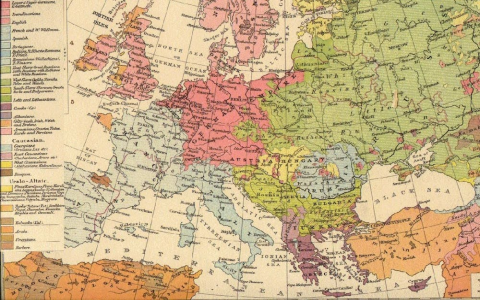
Started clicking on a few images. Saw the familiar outlines, but honestly? Many were just way too complicated. Colors everywhere, tiny labels I could barely read, arrows pointing every which way. I sat there squinting, thinking “What even happened to Austria? Where did Hungary go?” Felt kinda dumb not grasping it immediately.
Got frustrated quick. Needed a better approach. Forgot the fancy infographics, went back to basics. Decided to search specifically for “ww1 europe simplified map changes”. That helped. Found a couple that stripped it down to the big winners and losers.
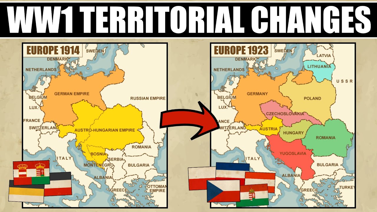
Digging into the Big Shifts
Okay, focused now. I wrote down a little list to keep track of the massive changes:
- Germany: Holy cow, they lost huge chunks! Obviously Alsace-Lorraine back to France – knew that one. But seeing them lose land to Poland, like that corridor cutting them off? Harsh. Plus bits to Belgium and Denmark.
- Austria-Hungary: This one blew my mind. That whole empire just vanished. Poof! On the ‘after’ map, it’s all these new little countries like Czechoslovakia and Yugoslavia. Hungary shrunk down to a fraction. Austria became this tiny landlocked state. Felt weird seeing it.
- Ottoman Empire: Same deal. Basically shattered. Turkey became way smaller, and chunks of the Middle East got handed off to France and Britain? Stuff I kinda knew happened later, but apparently the carving started right then. Made a note to dig into the Middle East part another time, it felt huge.
- Russia: Out early because of their revolution, right? The map showed them losing big territories in the west – Finland, Estonia, Latvia, Lithuania became independent. Poland also got a piece from them. Total mess.
- New Kids: That’s what really jumped out – Poland back on the map after ages, plus Czechoslovakia, Yugoslavia, Hungary suddenly separate… Crazy.
Drew a rough map in my notebook – a blob for Germany, shaded in the parts it lost. Drew Austria-Hungary then split it into pieces labeled ‘Czech’, ‘Yugo’, ‘Austria’, ‘Hungary’. Looks messy, but helped me visualize the breakup.
Why It Mattered (To Me Anyway)
Staring at my crude drawing, it finally clicked why people say the WW1 map was a setup for trouble. All these new borders, groups of people suddenly living in countries they didn’t pick, the anger bubbling under…
It wasn’t just a geography lesson. Seeing how they redrew the lines made things like why Germany felt screwed over super obvious. Or why tensions exploded later in Yugoslavia decades down the line. It wasn’t just lines on paper; it was moving millions of people into new situations they didn’t ask for. Kinda heavy.
Anyway, spent maybe an hour total clicking, squinting, getting mildly irritated, then having the “aha!” moments. Didn’t become an expert, but I definitely don’t feel vague about it anymore. It’s wild how much those decisions from over a hundred years ago are still echoing.